Tocht Noords wandelen Font-Romeu-Odeillo-Via - mauroux - Photo
 oliviercaty
oliviercaty

Gebruiker

© OpenStreetMap contributors
Lengte
Lengte
11,2 km
Max. hoogte
Max. hoogte
2127 m
Positief hoogteverschil
269 m
Km-Effort
Km-Effort  
14,7 km
Min. hoogte
Min. hoogte
1995 m
Negatief hoogteverschil
269 m
Boucle
Boucle
Ja
Datum van aanmaak :
2014-12-10 00:00:00.0
Laatste wijziging :
2014-12-10 00:00:00.0

(2 Bericht)

Noords wandelen
Noords wandelen
1h20
Moeilijkheid : Medium

Scan deze QR-code om de tocht te openen in de SityTrail-applicatie

Gratisgps-wandelapplicatie

Logo SityTrail SityTrail

IGN / Geografische instituten

SityTrail uit de App Store downloaden SityTrail uit Google Play downloaden

Logo SityTrail SityTrail World

De wereld gaat voor u open

SityTrail uit de App Store downloaden SityTrail uit Google Play downloaden SityTrail op Huawei AppGallery downloaden

Over ons

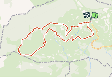
Tocht Noords wandelen van 11,2 km beschikbaar op Occitanië, Pyrénées-Orientales, Font-Romeu-Odeillo-Via. Deze tocht wordt voorgesteld door oliviercaty.

Hoogteprofiel

Plaatsbepaling

Land:
France
Regio :
Occitanië
Departement/Provincie :
Pyrénées-Orientales
Gemeente :
Font-Romeu-Odeillo-Via
Locatie:
Unknown
Vertrek:(Dec)
Vertrek:(UTM)
419540 ; 4709048 (31T) N.

Opmerkingen

Gelieve in te loggen om een commentaar of een beoordeling achter te laten


très joli parcours .Nous y avons vu un loup puis un peu plus loin une biche et son faon. Le parcours est varié très humide après le refuge de la calme.


Wandeltochten in de omgeving

Tocht Stappen Font-Romeu-Odeillo-Via - Coll del Pam lac des  Bouillouses - Photo
Stappen
jcmartin

Stappen

Medium
(2)
Font-Romeu-Odeillo-Via, Occitanië, Pyrénées-Orientales, France
13,3 km | 19,3 km-effort
4h 10min
Ja
Tocht Sneeuwschoenen Font-Romeu-Odeillo-Via - pic dels moros - Photo
Sneeuwschoenen
jpipacific

Sneeuwschoenen

Medium
(1)
Font-Romeu-Odeillo-Via, Occitanië, Pyrénées-Orientales, France
12,6 km | 19,4 km-effort
4h 46min
Ja
Tocht Sneeuwschoenen Les Angles - Lac d Aude -Refuge Bernardi les Angles - Photo
Sneeuwschoenen
MarieFrancoise

Sneeuwschoenen

Medium
(1)
Les Angles, Occitanië, Pyrénées-Orientales, France
13,9 km | 19,1 km-effort
5h 44min
Ja
Tocht Stappen Les Angles - le tour des lacs de carli - Photo
Stappen
mouss65

Stappen

Medium
(2)
Les Angles, Occitanië, Pyrénées-Orientales, France
11,4 km | 16,6 km-effort
3h 51min
Neen
Tocht Stappen Les Angles - Rando des 12 lacs - Photo
Stappen
stp130678

Stappen

Gemakkelijk
(1)
Les Angles, Occitanië, Pyrénées-Orientales, France
14,1 km | 20 km-effort
6h 30min
Ja
Tocht Stappen Font-Romeu-Odeillo-Via - Font Romeu Egat - Photo
Stappen
crijack

Stappen

Medium
(2)
Font-Romeu-Odeillo-Via, Occitanië, Pyrénées-Orientales, France
2,5 km | 3,4 km-effort
44min
Ja
Tocht Sneeuwschoenen Font-Romeu-Odeillo-Via - Pic dels Moros avec Pierre - Photo
Sneeuwschoenen
jpipacific

Sneeuwschoenen

Medium
(1)
Font-Romeu-Odeillo-Via, Occitanië, Pyrénées-Orientales, France
10,5 km | 15,9 km-effort
4h 4min
Ja
Tocht Stappen Égat - Egat  Puig  Moro - Photo
Stappen
ohelluin

Stappen

Medium
(1)
Égat, Occitanië, Pyrénées-Orientales, France
13,4 km | 19,3 km-effort
4h 51min
Ja
Tocht Stappen Égat - La croix d'Egat - Photo
Stappen
ochamley

Stappen

Gemakkelijk
(1)
Égat, Occitanië, Pyrénées-Orientales, France
7,1 km | 10,4 km-effort
2h 2min
Ja


Sluiten
Mijn abonnementen