


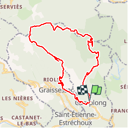
Le col du Liourel bis

xav34830
Gebruiker

Lengte
19,6 km

Max. hoogte
878 m

Positief hoogteverschil
704 m
Km-Effort
29 km

Min. hoogte
308 m

Negatief hoogteverschil
700 m
Boucle
Ja
Datum van aanmaak :
2014-12-10 00:00:00.0
Laatste wijziging :
2014-12-10 00:00:00.0
6h08
Moeilijkheid : Gemakkelijk

Gratisgps-wandelapplicatie
 SityTrail
IGN / Geografische instituten
SityTrail Plus
De wereld gaat voor u open
Over ons
Tocht Stappen van 19,6 km beschikbaar op Occitanië, Hérault, Camplong. Deze tocht wordt voorgesteld door xav34830.
Plaatsbepaling
Land:
France
Regio :
Occitanië
Departement/Provincie :
Hérault
Gemeente :
Camplong
Locatie:
Unknown
Vertrek:(Dec)
Vertrek:(UTM)
509531 ; 4835554 (31T) N.
Opmerkingen