


La Rheorthe

reva17
Gebruiker

Lengte
8,1 km

Max. hoogte
103 m

Positief hoogteverschil
147 m
Km-Effort
10,1 km

Min. hoogte
31 m

Negatief hoogteverschil
147 m
Boucle
Ja
Datum van aanmaak :
2014-12-10 00:00:00.0
Laatste wijziging :
2014-12-10 00:00:00.0
2h11
Moeilijkheid : Medium

Gratisgps-wandelapplicatie
 SityTrail
IGN / Geografische instituten
SityTrail Plus
De wereld gaat voor u open
Over ons
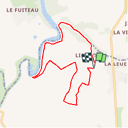
Tocht Stappen van 8,1 km beschikbaar op Pays de la Loire, Vendée, La Réorthe. Deze tocht wordt voorgesteld door reva17.
Beschrijving
Retenue de l'Angle Guignard Coteaux et vallons -Quelques passages difficiles
Plaatsbepaling
Land:
France
Regio :
Pays de la Loire
Departement/Provincie :
Vendée
Gemeente :
La Réorthe
Locatie:
Unknown
Vertrek:(Dec)
Vertrek:(UTM)
649418 ; 5166250 (30T) N.
Opmerkingen