


Cabane Rambert

pnoth
Gebruiker
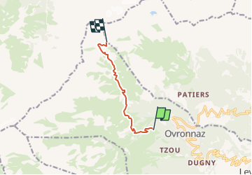

Lengte
6 km

Max. hoogte
2577 m

Positief hoogteverschil
1034 m
Km-Effort
16,6 km

Min. hoogte
1611 m

Negatief hoogteverschil
83 m
Boucle
Neen
Datum van aanmaak :
2014-12-11 00:00:00.0
Laatste wijziging :
2014-12-11 00:00:00.0
--
Moeilijkheid : Onbekend

Gratisgps-wandelapplicatie
 SityTrail
IGN / Geografische instituten
SityTrail Plus
De wereld gaat voor u open
Over ons
Tocht Andere activiteiten van 6 km beschikbaar op Valais/Wallis, Martigny, Leytron. Deze tocht wordt voorgesteld door pnoth.
Beschrijving
English: http://www.noth.ch/h0120_e.html
Français: http://www.noth.ch/h0120_f.html
Deutsch: http://www.noth.ch/h0120_d.html
Plaatsbepaling
Land:
Switzerland
Regio :
Valais/Wallis
Departement/Provincie :
Martigny
Gemeente :
Leytron
Locatie:
Unknown
Vertrek:(Dec)
Vertrek:(UTM)
357801 ; 5117947 (32T) N.
Opmerkingen