


2013-05-01 Balade a Wittisheim

holtzv
Gebruiker GUIDE
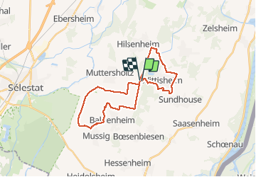

Lengte
28 km

Max. hoogte
173 m

Positief hoogteverschil
134 m
Km-Effort
30 km

Min. hoogte
159 m

Negatief hoogteverschil
137 m
Boucle
Ja
Datum van aanmaak :
2014-12-10 00:00:00.0
Laatste wijziging :
2014-12-10 00:00:00.0
6h27
Moeilijkheid : Heel gemakkelijk

Gratisgps-wandelapplicatie
 SityTrail
IGN / Geografische instituten
SityTrail Plus
De wereld gaat voor u open
Over ons
Tocht Paard van 28 km beschikbaar op Grand Est, Bas-Rhin, Wittisheim. Deze tocht wordt voorgesteld door holtzv.
Plaatsbepaling
Land:
France
Regio :
Grand Est
Departement/Provincie :
Bas-Rhin
Gemeente :
Wittisheim
Locatie:
Unknown
Vertrek:(Dec)
Vertrek:(UTM)
393651 ; 5346617 (32U) N.
Opmerkingen