


Circuit VDN Siersthal Peppenkum

Tourisme Equestre Alsace
Promouvoir le Tourisme Equestre en Alsace GUIDE+
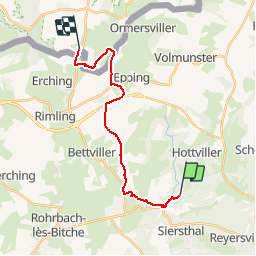

Lengte
16,3 km

Max. hoogte
376 m

Positief hoogteverschil
219 m
Km-Effort
19,4 km

Min. hoogte
261 m

Negatief hoogteverschil
282 m
Boucle
Neen
Datum van aanmaak :
2014-12-10 00:00:00.0
Laatste wijziging :
2019-01-05 18:44:08.545
2h25
Moeilijkheid : Gemakkelijk

Gratisgps-wandelapplicatie
 SityTrail
IGN / Geografische instituten
SityTrail Plus
De wereld gaat voor u open
Over ons
Tocht Paardrijden van 16,3 km beschikbaar op Grand Est, Moselle, Siersthal. Deze tocht wordt voorgesteld door Tourisme Equestre Alsace.
Foto's

Plaatsbepaling
Land:
France
Regio :
Grand Est
Departement/Provincie :
Moselle
Gemeente :
Siersthal
Locatie:
Unknown
Vertrek:(Dec)
Vertrek:(UTM)
379443 ; 5435400 (32U) N.
Opmerkingen