


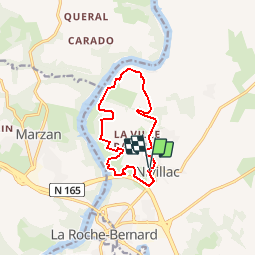
Rando autour de Nivillac

cess44
Gebruiker

Lengte
11 km

Max. hoogte
57 m

Positief hoogteverschil
173 m
Km-Effort
13,3 km

Min. hoogte
0 m

Negatief hoogteverschil
169 m
Boucle
Ja
Datum van aanmaak :
2014-12-10 00:00:00.0
Laatste wijziging :
2014-12-10 00:00:00.0
2h53
Moeilijkheid : Gemakkelijk

Gratisgps-wandelapplicatie
 SityTrail
IGN / Geografische instituten
SityTrail Plus
De wereld gaat voor u open
Over ons
Tocht Stappen van 11 km beschikbaar op Bretagne, Morbihan, Nivillac. Deze tocht wordt voorgesteld door cess44.
Plaatsbepaling
Land:
France
Regio :
Bretagne
Departement/Provincie :
Morbihan
Gemeente :
Nivillac
Locatie:
Unknown
Vertrek:(Dec)
Vertrek:(UTM)
553755 ; 5264689 (30T) N.
Opmerkingen