


tendon

michelelfn
Gebruiker
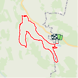

Lengte
9,1 km

Max. hoogte
699 m

Positief hoogteverschil
286 m
Km-Effort
12,9 km

Min. hoogte
504 m

Negatief hoogteverschil
292 m
Boucle
Ja
Datum van aanmaak :
2014-12-10 00:00:00.0
Laatste wijziging :
2014-12-10 00:00:00.0
3h01
Moeilijkheid : Gemakkelijk

Gratisgps-wandelapplicatie
 SityTrail
IGN / Geografische instituten
SityTrail Plus
De wereld gaat voor u open
Over ons
Tocht Stappen van 9,1 km beschikbaar op Grand Est, Vogezen, Le Tholy. Deze tocht wordt voorgesteld door michelelfn.
Beschrijving
tendon
Plaatsbepaling
Land:
France
Regio :
Grand Est
Departement/Provincie :
Vogezen
Gemeente :
Le Tholy
Locatie:
Unknown
Vertrek:(Dec)
Vertrek:(UTM)
328630 ; 5329984 (32U) N.
Opmerkingen
Très belle rando entre bois et cascades.