Tocht Stappen Illy - Chemin des contrebandiers - Illy - Photo

Chemin des contrebandiers - Illy

 tracegps
tracegps

Gebruiker

© OpenStreetMap contributors
Lengte
Lengte
7,9 km
Max. hoogte
Max. hoogte
312 m
Positief hoogteverschil
153 m
Km-Effort
Km-Effort  
9,9 km
Min. hoogte
Min. hoogte
230 m
Negatief hoogteverschil
153 m
Boucle
Boucle
Ja
Datum van aanmaak :
2014-12-10 00:00:00.0
Laatste wijziging :
2014-12-10 00:00:00.0

(2 Bericht)

Stappen
Stappen
1h55
Moeilijkheid : Gemakkelijk

Scan deze QR-code om de tocht te openen in de SityTrail-applicatie

Gratisgps-wandelapplicatie

Logo SityTrail SityTrail

IGN / Geografische instituten

SityTrail uit de App Store downloaden SityTrail uit Google Play downloaden

Logo SityTrail SityTrail World

De wereld gaat voor u open

SityTrail uit de App Store downloaden SityTrail uit Google Play downloaden SityTrail op Huawei AppGallery downloaden

Over ons

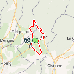
Tocht Stappen van 7,9 km beschikbaar op Grand Est, Ardennes, Illy. Deze tocht wordt voorgesteld door tracegps.

Beschrijving

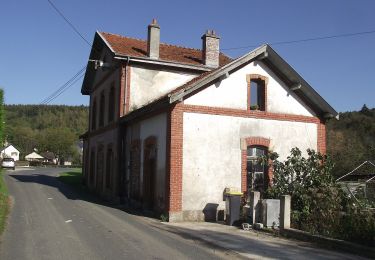
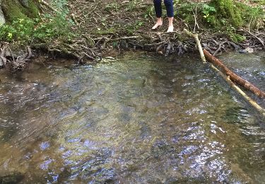
Départ de la mairie d'ILLY. le chemin prend la direction de la forêts puis descend à La Hatrelle où il y a une maison forte qui a résisté en 1940 (impactes de tir), traversez la rivière prendre à droite pour rejoindre le tracé du Bouillonnais(chemin de fer Sedan-Bouillon, arrêté en 1933) plusieurs tranchées taillées dans le schiste, point de vue sur la rivière en contrebas. Passez devant la château d'Olly (ancienne filature), en face monument de soldats morts en 1970. Voir l'ancienne gare transfrontalière d'lly. Retour sur ILLY église et temple du 19 ème.

Hoogteprofiel

Foto's

Plaatsbepaling

Land:
France
Regio :
Grand Est
Departement/Provincie :
Ardennes
Gemeente :
Illy
Locatie:
Unknown
Vertrek:(Dec)
Vertrek:(UTM)
641302 ; 5511078 (31U) N.

Opmerkingen

Gelieve in te loggen om een commentaar of een beoordeling achter te laten


Wandeltochten in de omgeving

Tocht Stappen Illy - départ d'Olly, arrivée au milieu de la forêt domaniale de Sedan, Ardennes - Photo
Stappen
jeff2

Stappen

Medium
Illy, Grand Est, Ardennes, France
28 km | 36 km-effort
8h 51min
Neen
Tocht Mountainbike Sedan - 20191006 Yeyette sur la voie verte à Sedan  - Photo
Mountainbike

Mountainbike

Sedan, Grand Est, Ardennes, France
37 km | 44 km-effort
6h 23min
Ja
Tocht Noords wandelen Saint-Menges - Saint Menges FFSP 4/9/22 - Photo
Noords wandelen
olidri

Noords wandelen

Moeilijk
Saint-Menges, Grand Est, Ardennes, France
21 km | 27 km-effort
3h 17min
Ja
Tocht Te voet Illy - Sentier du Bois Talot - Photo
Te voet
PRO

Te voet

Gemakkelijk
Illy, Grand Est, Ardennes, France
7,9 km | 10 km-effort
2h 15min
Ja
Tocht Mountainbike La Chapelle - 20191004 Yeyette à Givonne jour 1 - Photo
Mountainbike

Mountainbike

Moeilijk
La Chapelle, Grand Est, Ardennes, France
26 km | 33 km-effort
3h 1min
Ja
Tocht Stappen Givonne - FORÊT DE GIVONNES - Photo
Stappen
PascalBanide

Stappen

Gemakkelijk
Givonne, Grand Est, Ardennes, France
11,6 km | 14,6 km-effort
3h 26min
Ja
Tocht Stappen Illy - Le sentier du bois Talot - Photo
Stappen
Geronimo2010

Stappen

Heel gemakkelijk
Illy, Grand Est, Ardennes, France
9,3 km | 11,7 km-effort
2h 16min
Ja
Tocht Mountainbike Givonne - Espace VTT FFC Pays Sedanais Le Banet - Circuit n° 12 - Photo
Mountainbike
tracegps

Mountainbike

Moeilijk
Givonne, Grand Est, Ardennes, France
40 km | 51 km-effort
4h 0min
Ja
Tocht Mountainbike Givonne - Espace VTT FFC Pays Sedanais Le Banet - Circuit n° 11 - Photo
Mountainbike
tracegps

Mountainbike

Moeilijk
(1)
Givonne, Grand Est, Ardennes, France
35 km | 43 km-effort
3h 0min
Ja


Sluiten
Mijn abonnementen