Tocht Stappen Peyrus - Le Pas du Touet - Le Pas Saint-Vincent - Photo

Le Pas du Touet - Le Pas Saint-Vincent

 Philindy26
Philindy26

Gebruiker

© OpenStreetMap contributors
Lengte
Lengte
15,1 km
Max. hoogte
Max. hoogte
1115 m
Positief hoogteverschil
868 m
Km-Effort
Km-Effort  
27 km
Min. hoogte
Min. hoogte
390 m
Negatief hoogteverschil
868 m
Boucle
Boucle
Ja
Datum van aanmaak :
2018-07-08 12:41:19.647
Laatste wijziging :
2020-09-28 18:21:28.713

(0 Bericht)

Stappen
Stappen
5h15
Moeilijkheid : Moeilijk

Scan deze QR-code om de tocht te openen in de SityTrail-applicatie

Gratisgps-wandelapplicatie

Logo SityTrail SityTrail

IGN / Geografische instituten

SityTrail uit de App Store downloaden SityTrail uit Google Play downloaden

Logo SityTrail SityTrail Plus

De wereld gaat voor u open

SityTrail uit de App Store downloaden SityTrail uit Google Play downloaden SityTrail op Huawei AppGallery downloaden

Over ons

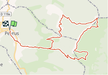
Tocht Stappen van 15,1 km beschikbaar op Auvergne-Rhône-Alpes, Drôme, Peyrus. Deze tocht wordt voorgesteld door Philindy26.

Beschrijving

Départ de Peyrus, D68 direction le col des Limouches...
Géolocalisation (Google Maps) : https://goo.gl/maps/X2XxyHGvCgf8BCUi7 .
Montez au pas du Touet (1051 m) par le GR93 et suivre les crêtes en passant par le pylône de télécommunications.
Descente par le pas de Saint-Vincent (1112 m) et les Rochers de la Drayette.
Puis direction les Chabottes, les ruines des Blachons (667 m), les Vachères et Peyrus.

Hoogteprofiel

Foto's

23 fotos in totaal. Klik op een foto om ze allemaal in de galerij weer te geven.

Plaatsbepaling

Land:
France
Regio :
Auvergne-Rhône-Alpes
Departement/Provincie :
Drôme
Gemeente :
Peyrus
Locatie:
Unknown
Vertrek:(UTM)
666488 ; 4975489 (31T) N.


Sluiten
Mijn abonnementen