


Croix du Montaiguet

counoise
Gebruiker

Lengte
13,9 km

Max. hoogte
305 m

Positief hoogteverschil
280 m
Km-Effort
17,6 km

Min. hoogte
131 m

Negatief hoogteverschil
280 m
Boucle
Ja
Datum van aanmaak :
2018-07-08 12:46:32.285
Laatste wijziging :
2018-07-08 16:12:26.701
3h21
Moeilijkheid : Gemakkelijk

Gratisgps-wandelapplicatie
 SityTrail
IGN / Geografische instituten
SityTrail Plus
De wereld gaat voor u open
Over ons
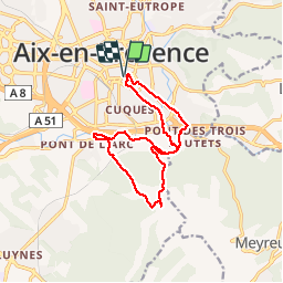
Tocht Stappen van 13,9 km beschikbaar op Provence-Alpes-Côte d'Azur, Bouches-du-Rhône, Aix-en-Provence. Deze tocht wordt voorgesteld door counoise.
Beschrijving
La Croix du Montaiguet en boucle depuis le centre d'Aix
Plaatsbepaling
Land:
France
Regio :
Provence-Alpes-Côte d'Azur
Departement/Provincie :
Bouches-du-Rhône
Gemeente :
Aix-en-Provence
Locatie:
Unknown
Vertrek:(Dec)
Vertrek:(UTM)
698112 ; 4821935 (31T) N.
Opmerkingen