


sortie vtt du 22072018 Frehaut

fabwin
Gebruiker GUIDE

Lengte
36 km

Max. hoogte
285 m

Positief hoogteverschil
283 m
Km-Effort
40 km

Min. hoogte
223 m

Negatief hoogteverschil
283 m
Boucle
Ja
Datum van aanmaak :
2018-07-22 07:04:11.74
Laatste wijziging :
2018-07-22 09:57:31.098
2h20
Moeilijkheid : Medium

Gratisgps-wandelapplicatie
 SityTrail
IGN / Geografische instituten
SityTrail Plus
De wereld gaat voor u open
Over ons
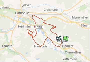
Tocht Mountainbike van 36 km beschikbaar op Grand Est, Meurthe-et-Moselle, Saint-Clément. Deze tocht wordt voorgesteld door fabwin.
Beschrijving
Avec David
test et validation.
les grosses roues c'est vraiment bien
Plaatsbepaling
Land:
France
Regio :
Grand Est
Departement/Provincie :
Meurthe-et-Moselle
Gemeente :
Saint-Clément
Locatie:
Unknown
Vertrek:(Dec)
Vertrek:(UTM)
323019 ; 5378532 (32U) N.
Opmerkingen