![](/images/other/stat-length.png)
![Tocht Motorfiets Loreux - GTA 2018 - ETAPE 1 - Photo](https://media.geolcdn.com/t/1900/400/ext.pjpeg?maxdim=2&url=https%3A%2F%2Fstatic1.geolcdn.com%2Fsiteimages%2Fupload%2Ffiles%2F1524743155moto.jpg)
GTA 2018 - ETAPE 1
lagardienne
Gebruiker
![Lengte](/images/other/stat-length.png)
Lengte
503 km
![Max. hoogte](https://static1.geolcdn.com/siteimages/upload/files/1508320355ic_sort_altitude_max_24dp.png)
Max. hoogte
1028 m
![Positief hoogteverschil](https://static1.geolcdn.com/siteimages/upload/files/1508320355ic_sort_den_pos_24dp.png)
Positief hoogteverschil
6316 m
![Km-Effort](/images/other/stat-length.png)
Km-Effort
586 km
![Min. hoogte](https://static1.geolcdn.com/siteimages/upload/files/1508320355ic_sort_altitude_min_24dp.png)
Min. hoogte
91 m
![Negatief hoogteverschil](https://static1.geolcdn.com/siteimages/upload/files/1508320355ic_sort_den_neg_24dp.png)
Negatief hoogteverschil
6033 m
![Boucle](https://static1.geolcdn.com/siteimages/upload/files/16400158638029165_repeat_loop_refresh_sync_direction_icon.png)
Boucle
Neen
Datum van aanmaak :
2018-07-24 12:09:28.994
Laatste wijziging :
2018-07-24 12:34:32.271
![Motorfiets](https://static1.geolcdn.com/sitytour/trail-icons/402.png)
7h40
Moeilijkheid : Gemakkelijk
![Scan deze QR-code om de tocht te openen in de SityTrail-applicatie](https://capi.geolives.com/qq0zvz2zws4bq2lad0pu/sitytour/trails/2004283/qr.png?size=200)
Gratisgps-wandelapplicatie
Over ons
Tocht Motorfiets van 503 km beschikbaar op Centre-Val de Loire, Loir-et-Cher, Loreux. Deze tocht wordt voorgesteld door lagardienne.
Beschrijving
Grande traversée des Alpes et Petites Routes du Soleil effectuées en moto.
Plus de détail sur http://lejardindelolo.fr/
3079 km en 12 jours, avec une Varadéro 125.
Plaatsbepaling
Land:
France
Regio :
Centre-Val de Loire
Departement/Provincie :
Loir-et-Cher
Gemeente :
Loreux
Locatie:
Unknown
Vertrek:(Dec)
Vertrek:(UTM)
411736 ; 5250129 (31T) N.
Opmerkingen
Wandeltochten in de omgeving
![Tocht Fiets Loreux - La route des étangs - Photo](https://media.geolcdn.com/t/375/260/ext.jpg?maxdim=2&url=https%3A%2F%2Fservices.sitytrail.com%2FGeolivesWS%2FDownloadMedia.ashx%3FTrailID%3D257209%26Media%3Dfix__20131111115040.jpg)
![Fiets Fiets](https://static1.geolcdn.com/sitytour/trail-icons/200.png)
La route des étangs
Fiets
Heel gemakkelijk
Loreux,
Centre-Val de Loire,
Loir-et-Cher,
France
![](/images/other/stat-length.png)
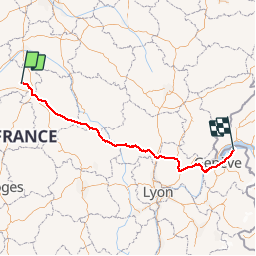
38 km | 42 km-effort
1h 51min
![](https://static1.geolcdn.com/siteimages/upload/files/16400158638029165_repeat_loop_refresh_sync_direction_icon.png)
Ja
![Tocht Mountainbike Loreux - canal de la sauldres - Photo](https://media.geolcdn.com/t/375/260/ext.jpg?maxdim=2&url=https%3A%2F%2Fservices.sitytrail.com%2FGeolivesWS%2FDownloadMedia.ashx%3FTrailID%3D460515%26Media%3Dfix__20150808082726.jpg)
![Mountainbike Mountainbike](https://static1.geolcdn.com/sitytour/trail-icons/202.png)
canal de la sauldres
Mountainbike
Medium
Loreux,
Centre-Val de Loire,
Loir-et-Cher,
France
![](/images/other/stat-length.png)
104 km | 114 km-effort
12h 5min
![](https://static1.geolcdn.com/siteimages/upload/files/16400158638029165_repeat_loop_refresh_sync_direction_icon.png)
Neen
![Tocht Wegfiets Romorantin-Lanthenay - romo marcilly romo - Photo](https://media.geolcdn.com/t/375/260/ext.jpg?maxdim=2&url=https%3A%2F%2Fstatic1.geolcdn.com%2Fsiteimages%2Fupload%2Ffiles%2F1524743154velo.jpg)
![Wegfiets Wegfiets](https://static1.geolcdn.com/sitytour/trail-icons/201.png)
romo marcilly romo
Wegfiets
Heel gemakkelijk
Romorantin-Lanthenay,
Centre-Val de Loire,
Loir-et-Cher,
France
![](/images/other/stat-length.png)
40 km | 44 km-effort
1h 48min
![](https://static1.geolcdn.com/siteimages/upload/files/16400158638029165_repeat_loop_refresh_sync_direction_icon.png)
Ja
![Tocht Stappen Villeherviers - villeherviers - Photo](https://media.geolcdn.com/t/375/260/ext.jpg?maxdim=2&url=https%3A%2F%2Fstatic1.geolcdn.com%2Fsiteimages%2Fupload%2Ffiles%2F1553511878bg_sport_marche.png)
![Stappen Stappen](https://static1.geolcdn.com/sitytour/trail-icons/101.png)
villeherviers
Stappen
Gemakkelijk
Villeherviers,
Centre-Val de Loire,
Loir-et-Cher,
France
![](/images/other/stat-length.png)
7,8 km | 8,5 km-effort
1h 51min
![](https://static1.geolcdn.com/siteimages/upload/files/16400158638029165_repeat_loop_refresh_sync_direction_icon.png)
Ja
![Tocht Stappen Villeherviers - villeherviers - Photo](https://media.geolcdn.com/t/375/260/ext.jpg?maxdim=2&url=https%3A%2F%2Fstatic1.geolcdn.com%2Fsiteimages%2Fupload%2Ffiles%2F1553511878bg_sport_marche.png)
![Stappen Stappen](https://static1.geolcdn.com/sitytour/trail-icons/101.png)
villeherviers
Stappen
Heel gemakkelijk
Villeherviers,
Centre-Val de Loire,
Loir-et-Cher,
France
![](/images/other/stat-length.png)
7,2 km | 7,8 km-effort
1h 53min
![](https://static1.geolcdn.com/siteimages/upload/files/16400158638029165_repeat_loop_refresh_sync_direction_icon.png)
Ja
![Tocht Mountainbike Loreux - loreux guerigny - Photo](https://media.geolcdn.com/t/375/260/ext.jpg?maxdim=2&url=https%3A%2F%2Fstatic1.geolcdn.com%2Fsiteimages%2Fupload%2Ffiles%2F1524743154velo.jpg)
![Mountainbike Mountainbike](https://static1.geolcdn.com/sitytour/trail-icons/202.png)
loreux guerigny
Mountainbike
Medium
Loreux,
Centre-Val de Loire,
Loir-et-Cher,
France
![](/images/other/stat-length.png)
130 km | 147 km-effort
8h 53min
![](https://static1.geolcdn.com/siteimages/upload/files/16400158638029165_repeat_loop_refresh_sync_direction_icon.png)
Neen
![Tocht Fiets Romorantin-Lanthenay - romo menetou romo - Photo](https://media.geolcdn.com/t/375/260/ext.jpg?maxdim=2&url=https%3A%2F%2Fstatic1.geolcdn.com%2Fsiteimages%2Fupload%2Ffiles%2F1524743154velo.jpg)
![Fiets Fiets](https://static1.geolcdn.com/sitytour/trail-icons/200.png)
romo menetou romo
Fiets
Heel gemakkelijk
Romorantin-Lanthenay,
Centre-Val de Loire,
Loir-et-Cher,
France
![](/images/other/stat-length.png)
36 km | 40 km-effort
2h 0min
![](https://static1.geolcdn.com/siteimages/upload/files/16400158638029165_repeat_loop_refresh_sync_direction_icon.png)
Ja
![Tocht Wegfiets Romorantin-Lanthenay - romo loreux salbris rte teillay ferthe Imbault romo - Photo](https://media.geolcdn.com/t/375/260/ext.jpg?maxdim=2&url=https%3A%2F%2Fstatic1.geolcdn.com%2Fsiteimages%2Fupload%2Ffiles%2F1524743154velo.jpg)
![Wegfiets Wegfiets](https://static1.geolcdn.com/sitytour/trail-icons/201.png)
romo loreux salbris rte teillay ferthe Imbault romo
Wegfiets
Heel gemakkelijk
Romorantin-Lanthenay,
Centre-Val de Loire,
Loir-et-Cher,
France
![](/images/other/stat-length.png)
57 km | 63 km-effort
2h 10min
![](https://static1.geolcdn.com/siteimages/upload/files/16400158638029165_repeat_loop_refresh_sync_direction_icon.png)
Ja
![Tocht Wegfiets Romorantin-Lanthenay - Romo Pruniers Mur Courmemin Veillens Romo - Photo](https://media.geolcdn.com/t/375/260/ext.jpg?maxdim=2&url=https%3A%2F%2Fstatic1.geolcdn.com%2Fsiteimages%2Fupload%2Ffiles%2F1524743154velo.jpg)
![Wegfiets Wegfiets](https://static1.geolcdn.com/sitytour/trail-icons/201.png)
Romo Pruniers Mur Courmemin Veillens Romo
Wegfiets
Heel gemakkelijk
Romorantin-Lanthenay,
Centre-Val de Loire,
Loir-et-Cher,
France
![](/images/other/stat-length.png)
62 km | 68 km-effort
2h 30min
![](https://static1.geolcdn.com/siteimages/upload/files/16400158638029165_repeat_loop_refresh_sync_direction_icon.png)
Ja