


sortie vtt du 27072018 nocturne

fabwin
Gebruiker GUIDE
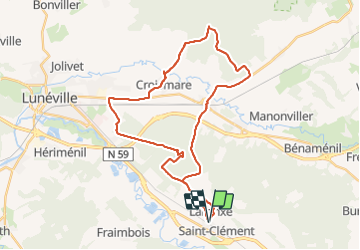

Lengte
46 km

Max. hoogte
285 m

Positief hoogteverschil
292 m
Km-Effort
50 km

Min. hoogte
224 m

Negatief hoogteverschil
293 m
Boucle
Ja
Datum van aanmaak :
2018-07-27 17:43:05.466
Laatste wijziging :
2018-07-28 10:38:43.31
1h52
Moeilijkheid : Medium

Gratisgps-wandelapplicatie
 SityTrail
IGN / Geografische instituten
SityTrail Plus
De wereld gaat voor u open
Over ons
Tocht Mountainbike van 46 km beschikbaar op Grand Est, Meurthe-et-Moselle, Saint-Clément. Deze tocht wordt voorgesteld door fabwin.
Foto's


Plaatsbepaling
Land:
France
Regio :
Grand Est
Departement/Provincie :
Meurthe-et-Moselle
Gemeente :
Saint-Clément
Locatie:
Unknown
Vertrek:(Dec)
Vertrek:(UTM)
323007 ; 5378512 (32U) N.
Opmerkingen