


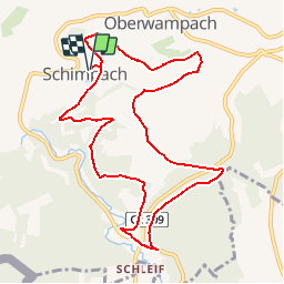
Autopedestres : Schimpach

Visit Luxembourg
Randonnées de Visit Luxembourg. GUIDE+

Lengte
9,8 km

Max. hoogte
492 m

Positief hoogteverschil
248 m
Km-Effort
13,1 km

Min. hoogte
357 m

Negatief hoogteverschil
248 m
Boucle
Ja
Datum van aanmaak :
2014-12-10 00:00:00.0
Laatste wijziging :
2014-12-10 00:00:00.0
--
Moeilijkheid : Onbekend

Gratisgps-wandelapplicatie
 SityTrail
IGN / Geografische instituten
SityTrail Plus
De wereld gaat voor u open
Over ons
Tocht Stappen van 9,8 km beschikbaar op Onbekend, Canton Clervaux, Wincrange. Deze tocht wordt voorgesteld door Visit Luxembourg.


Plaatsbepaling
Land:
Luxembourg
Regio :
Onbekend
Departement/Provincie :
Canton Clervaux
Gemeente :
Wincrange
Locatie:
Unknown
Vertrek:(Dec)
Vertrek:(UTM)
704129 ; 5543632 (31U) N.
Opmerkingen