


betharam RS

LouisROGER
Gebruiker GUIDE
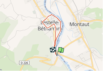

Lengte
2,7 km

Max. hoogte
317 m

Positief hoogteverschil
30 m
Km-Effort
3,1 km

Min. hoogte
296 m

Negatief hoogteverschil
30 m
Boucle
Ja
Datum van aanmaak :
2018-10-01 08:19:54.838
Laatste wijziging :
2018-10-01 08:20:54.515
40m
Moeilijkheid : Gemakkelijk

Gratisgps-wandelapplicatie
 SityTrail
IGN / Geografische instituten
SityTrail Plus
De wereld gaat voor u open
Over ons
Tocht Stappen van 2,7 km beschikbaar op Nieuw-Aquitanië, Pyrénées-Atlantiques, Lestelle-Bétharram. Deze tocht wordt voorgesteld door LouisROGER.
Plaatsbepaling
Land:
France
Regio :
Nieuw-Aquitanië
Departement/Provincie :
Pyrénées-Atlantiques
Gemeente :
Lestelle-Bétharram
Locatie:
Unknown
Vertrek:(Dec)
Vertrek:(UTM)
727228 ; 4778233 (30T) N.
Opmerkingen