


ACTIVE LOG

LouisROGER
Gebruiker GUIDE
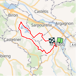

Lengte
11,9 km

Max. hoogte
99 m

Positief hoogteverschil
101 m
Km-Effort
13,2 km

Min. hoogte
68 m

Negatief hoogteverschil
102 m
Boucle
Ja
Datum van aanmaak :
2018-11-21 18:44:37.948
Laatste wijziging :
2018-11-21 18:48:12.875
2h55
Moeilijkheid : Moeilijk

Gratisgps-wandelapplicatie
 SityTrail
IGN / Geografische instituten
SityTrail Plus
De wereld gaat voor u open
Over ons
Tocht Stappen van 11,9 km beschikbaar op Nieuw-Aquitanië, Pyrénées-Atlantiques, Maslacq. Deze tocht wordt voorgesteld door LouisROGER.
Plaatsbepaling
Land:
France
Regio :
Nieuw-Aquitanië
Departement/Provincie :
Pyrénées-Atlantiques
Gemeente :
Maslacq
Locatie:
Unknown
Vertrek:(Dec)
Vertrek:(UTM)
686467 ; 4812088 (30T) N.
Opmerkingen