


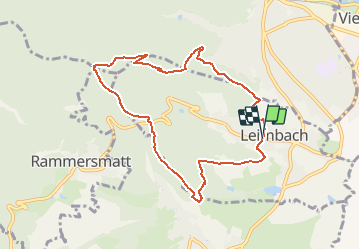
Leimbach - Chalet Zuber

patrickbeyrath
Gebruiker

Lengte
8,5 km

Max. hoogte
647 m

Positief hoogteverschil
341 m
Km-Effort
13 km

Min. hoogte
357 m

Negatief hoogteverschil
337 m
Boucle
Ja
Datum van aanmaak :
2018-12-07 08:21:02.977
Laatste wijziging :
2018-12-07 08:27:56.896
2h42
Moeilijkheid : Medium

Gratisgps-wandelapplicatie
 SityTrail
IGN / Geografische instituten
SityTrail Plus
De wereld gaat voor u open
Over ons
Tocht Stappen van 8,5 km beschikbaar op Grand Est, Haut-Rhin, Leimbach. Deze tocht wordt voorgesteld door patrickbeyrath.
Beschrijving
Parking mairie Leimbach - Les Trois Chênes ) Tempel - Muhlberg - Col du Teufelsgrund - Chalet Zuber - descente rond rouge puis prendre à gauche Riegelsbourg et retour parking
Plaatsbepaling
Land:
France
Regio :
Grand Est
Departement/Provincie :
Haut-Rhin
Gemeente :
Leimbach
Locatie:
Unknown
Vertrek:(Dec)
Vertrek:(UTM)
357786 ; 5295059 (32T) N.
Opmerkingen