


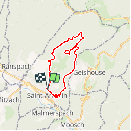
St Amarin - Meerbaechlé par la vue des Alpes

patrickbeyrath
Gebruiker

Lengte
11,7 km

Max. hoogte
859 m

Positief hoogteverschil
570 m
Km-Effort
19,3 km

Min. hoogte
420 m

Negatief hoogteverschil
569 m
Boucle
Ja
Datum van aanmaak :
2019-01-01 12:39:17.564
Laatste wijziging :
2019-01-04 10:18:54.694
--
Moeilijkheid : Medium

Gratisgps-wandelapplicatie
 SityTrail
IGN / Geografische instituten
SityTrail Plus
De wereld gaat voor u open
Over ons
Tocht Te voet van 11,7 km beschikbaar op Grand Est, Haut-Rhin, Saint-Amarin. Deze tocht wordt voorgesteld door patrickbeyrath.
Plaatsbepaling
Land:
France
Regio :
Grand Est
Departement/Provincie :
Haut-Rhin
Gemeente :
Saint-Amarin
Locatie:
Unknown
Vertrek:(Dec)
Vertrek:(UTM)
352869 ; 5304367 (32T) N.
Opmerkingen