


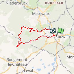
Lauw - Trois Bornes - Le Vieux Château - Abri Oberen Grambaechlé - Lac Bleu - Lauw

patrickbeyrath
Gebruiker

Lengte
11,4 km

Max. hoogte
790 m

Positief hoogteverschil
474 m
Km-Effort
17,8 km

Min. hoogte
378 m

Negatief hoogteverschil
475 m
Boucle
Ja
Datum van aanmaak :
2019-01-04 08:05:06.345
Laatste wijziging :
2019-01-04 09:06:44.956
--
Moeilijkheid : Medium

Gratisgps-wandelapplicatie
 SityTrail
IGN / Geografische instituten
SityTrail Plus
De wereld gaat voor u open
Over ons
Tocht Te voet van 11,4 km beschikbaar op Grand Est, Haut-Rhin, Lauw. Deze tocht wordt voorgesteld door patrickbeyrath.
Plaatsbepaling
Land:
France
Regio :
Grand Est
Departement/Provincie :
Haut-Rhin
Gemeente :
Lauw
Locatie:
Unknown
Vertrek:(Dec)
Vertrek:(UTM)
351220 ; 5291100 (32T) N.
Opmerkingen