


la pointe du menhir 2019 PM

LaurentBernard
Gebruiker
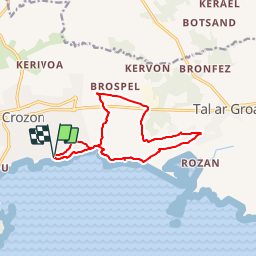

Lengte
11,8 km

Max. hoogte
83 m

Positief hoogteverschil
209 m
Km-Effort
14,7 km

Min. hoogte
4 m

Negatief hoogteverschil
229 m
Boucle
Ja
Datum van aanmaak :
2019-01-11 10:07:53.376
Laatste wijziging :
2019-01-13 10:47:45.731
--
Moeilijkheid : Heel gemakkelijk

Gratisgps-wandelapplicatie
 SityTrail
IGN / Geografische instituten
SityTrail Plus
De wereld gaat voor u open
Over ons
Tocht Te voet van 11,8 km beschikbaar op Bretagne, Finistère, Crozon. Deze tocht wordt voorgesteld door LaurentBernard.
Plaatsbepaling
Land:
France
Regio :
Bretagne
Departement/Provincie :
Finistère
Gemeente :
Crozon
Locatie:
Unknown
Vertrek:(Dec)
Vertrek:(UTM)
390211 ; 5343733 (30U) N.
Opmerkingen