


Argol 2019

LaurentBernard
Gebruiker
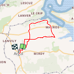

Lengte
11,3 km

Max. hoogte
111 m

Positief hoogteverschil
218 m
Km-Effort
14,2 km

Min. hoogte
17 m

Negatief hoogteverschil
218 m
Boucle
Ja
Datum van aanmaak :
2019-01-11 15:00:18.104
Laatste wijziging :
2019-01-11 15:01:04.701
--
Moeilijkheid : Heel gemakkelijk

Gratisgps-wandelapplicatie
 SityTrail
IGN / Geografische instituten
SityTrail Plus
De wereld gaat voor u open
Over ons
Tocht Te voet van 11,3 km beschikbaar op Bretagne, Finistère, Argol. Deze tocht wordt voorgesteld door LaurentBernard.
Plaatsbepaling
Land:
France
Regio :
Bretagne
Departement/Provincie :
Finistère
Gemeente :
Argol
Locatie:
Unknown
Vertrek:(Dec)
Vertrek:(UTM)
402268 ; 5344532 (30U) N.
Opmerkingen