


Wizernes 9.1Km Dén P 151m

alain62rando
Gebruiker
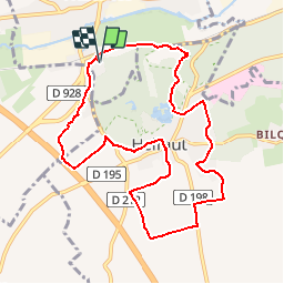

Lengte
9,1 km

Max. hoogte
95 m

Positief hoogteverschil
151 m
Km-Effort
11,1 km

Min. hoogte
24 m

Negatief hoogteverschil
150 m
Boucle
Ja
Datum van aanmaak :
2019-01-17 19:06:26.143
Laatste wijziging :
2019-02-10 15:21:59.353
--
Moeilijkheid : Medium

Gratisgps-wandelapplicatie
 SityTrail
IGN / Geografische instituten
SityTrail Plus
De wereld gaat voor u open
Over ons
Tocht Te voet van 9,1 km beschikbaar op Hauts-de-France, Pas-de-Calais, Wizernes. Deze tocht wordt voorgesteld door alain62rando.
Plaatsbepaling
Land:
France
Regio :
Hauts-de-France
Departement/Provincie :
Pas-de-Calais
Gemeente :
Wizernes
Locatie:
Unknown
Vertrek:(Dec)
Vertrek:(UTM)
445717 ; 5617267 (31U) N.
Opmerkingen