


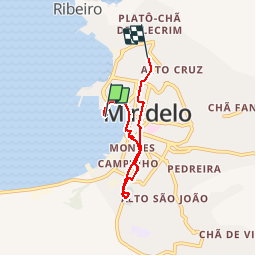
Arrivée à Mindelo

PatriceCocuaud
Gebruiker

Lengte
6,7 km

Max. hoogte
43 m

Positief hoogteverschil
92 m
Km-Effort
7,8 km

Min. hoogte
0 m

Negatief hoogteverschil
53 m
Boucle
Neen
Datum van aanmaak :
2019-02-07 17:59:27.448
Laatste wijziging :
2019-02-07 21:15:52.031
2h16
Moeilijkheid : Heel gemakkelijk

Gratisgps-wandelapplicatie
 SityTrail
IGN / Geografische instituten
SityTrail Plus
De wereld gaat voor u open
Over ons
Tocht Stappen van 6,7 km beschikbaar op Onbekend, São Vicente. Deze tocht wordt voorgesteld door PatriceCocuaud.
Plaatsbepaling
Land:
Cape Verde
Regio :
Onbekend
Departement/Provincie :
São Vicente
Gemeente :
Mindelo
Locatie:
Unknown
Vertrek:(Dec)
Vertrek:(UTM)
713735 ; 1868112 (26Q) N.
Opmerkingen