


jurançonRs

LouisROGER
Gebruiker GUIDE
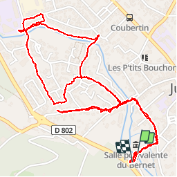

Lengte
4,2 km

Max. hoogte
180 m

Positief hoogteverschil
20 m
Km-Effort
4,5 km

Min. hoogte
168 m

Negatief hoogteverschil
21 m
Boucle
Ja
Datum van aanmaak :
2019-02-12 14:11:17.86
Laatste wijziging :
2019-02-12 16:45:46.825
2h33
Moeilijkheid : Heel gemakkelijk

Gratisgps-wandelapplicatie
 SityTrail
IGN / Geografische instituten
SityTrail Plus
De wereld gaat voor u open
Over ons
Tocht Stappen van 4,2 km beschikbaar op Nieuw-Aquitanië, Pyrénées-Atlantiques, Jurançon. Deze tocht wordt voorgesteld door LouisROGER.
Foto's


Plaatsbepaling
Land:
France
Regio :
Nieuw-Aquitanië
Departement/Provincie :
Pyrénées-Atlantiques
Gemeente :
Jurançon
Locatie:
Unknown
Vertrek:(Dec)
Vertrek:(UTM)
711478 ; 4795682 (30T) N.
Opmerkingen