


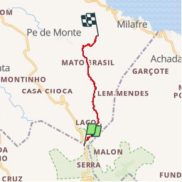
Sierra Malaguetta

PatriceCocuaud
Gebruiker

Lengte
8,7 km

Max. hoogte
792 m

Positief hoogteverschil
255 m
Km-Effort
13,8 km

Min. hoogte
241 m

Negatief hoogteverschil
774 m
Boucle
Neen
Datum van aanmaak :
2019-02-13 13:40:34.334
Laatste wijziging :
2019-02-13 18:59:17.134
3h15
Moeilijkheid : Heel gemakkelijk

Gratisgps-wandelapplicatie
 SityTrail
IGN / Geografische instituten
SityTrail Plus
De wereld gaat voor u open
Over ons
Tocht Stappen van 8,7 km beschikbaar op Onbekend, Santa Catarina. Deze tocht wordt voorgesteld door PatriceCocuaud.
Plaatsbepaling
Land:
Cape Verde
Regio :
Onbekend
Departement/Provincie :
Santa Catarina
Gemeente :
Malagueta
Locatie:
Unknown
Vertrek:(Dec)
Vertrek:(UTM)
210782 ; 1681466 (27P) N.
Opmerkingen