


table

pythonmichel
Gebruiker
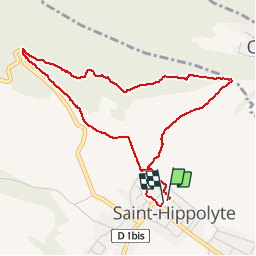

Lengte
4,3 km

Max. hoogte
414 m

Positief hoogteverschil
176 m
Km-Effort
6,7 km

Min. hoogte
245 m

Negatief hoogteverschil
176 m
Boucle
Ja
Datum van aanmaak :
2019-03-22 16:32:38.042
Laatste wijziging :
2019-03-22 19:46:17.377
55m
Moeilijkheid : Gemakkelijk

Gratisgps-wandelapplicatie
 SityTrail
IGN / Geografische instituten
SityTrail Plus
De wereld gaat voor u open
Over ons
Tocht Stappen van 4,3 km beschikbaar op Grand Est, Haut-Rhin, Saint-Hippolyte. Deze tocht wordt voorgesteld door pythonmichel.
Plaatsbepaling
Land:
France
Regio :
Grand Est
Departement/Provincie :
Haut-Rhin
Gemeente :
Saint-Hippolyte
Locatie:
Unknown
Vertrek:(Dec)
Vertrek:(UTM)
378908 ; 5343528 (32U) N.
Opmerkingen