


9756002-Coudray au Perche 19.46

togolo28
Gebruiker
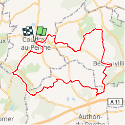

Lengte
19,5 km

Max. hoogte
272 m

Positief hoogteverschil
366 m
Km-Effort
24 km

Min. hoogte
153 m

Negatief hoogteverschil
367 m
Boucle
Ja
Datum van aanmaak :
2019-03-31 14:51:26.709
Laatste wijziging :
2019-03-31 14:51:57.67
5h15
Moeilijkheid : Medium

Gratisgps-wandelapplicatie
 SityTrail
IGN / Geografische instituten
SityTrail Plus
De wereld gaat voor u open
Over ons
Tocht Stappen van 19,5 km beschikbaar op Centre-Val de Loire, Eure-et-Loir, Coudray-au-Perche. Deze tocht wordt voorgesteld door togolo28.
Plaatsbepaling
Land:
France
Regio :
Centre-Val de Loire
Departement/Provincie :
Eure-et-Loir
Gemeente :
Coudray-au-Perche
Locatie:
Unknown
Vertrek:(Dec)
Vertrek:(UTM)
340735 ; 5344318 (31U) N.
Opmerkingen