


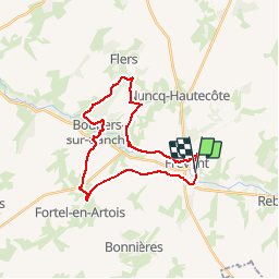
Frévent (3) 23.5Kms Dén P 319m

alain62rando
Gebruiker

Lengte
24 km

Max. hoogte
143 m

Positief hoogteverschil
319 m
Km-Effort
28 km

Min. hoogte
56 m

Negatief hoogteverschil
321 m
Boucle
Ja
Datum van aanmaak :
2019-04-06 17:30:08.828
Laatste wijziging :
2019-04-06 17:31:14.317
6h04
Moeilijkheid : Zeer moeilijk

Gratisgps-wandelapplicatie
 SityTrail
IGN / Geografische instituten
SityTrail Plus
De wereld gaat voor u open
Over ons
Tocht Stappen van 24 km beschikbaar op Hauts-de-France, Pas-de-Calais, Frévent. Deze tocht wordt voorgesteld door alain62rando.

Plaatsbepaling
Land:
France
Regio :
Hauts-de-France
Departement/Provincie :
Pas-de-Calais
Gemeente :
Frévent
Locatie:
Unknown
Vertrek:(Dec)
Vertrek:(UTM)
450009 ; 5569403 (31U) N.
Opmerkingen