


Fontjoncouse 07 04 2019

DENNEBECQ
Gebruiker

Lengte
71 km

Max. hoogte
414 m

Positief hoogteverschil
825 m
Km-Effort
82 km

Min. hoogte
55 m

Negatief hoogteverschil
972 m
Boucle
Neen
Datum van aanmaak :
2019-04-07 07:59:52.474
Laatste wijziging :
2019-04-15 20:38:49.959
6h31
Moeilijkheid : Gemakkelijk

Gratisgps-wandelapplicatie
 SityTrail
IGN / Geografische instituten
SityTrail Plus
De wereld gaat voor u open
Over ons
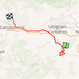
Tocht Stappen van 71 km beschikbaar op Occitanië, Aude, Fontjoncouse. Deze tocht wordt voorgesteld door DENNEBECQ.
Plaatsbepaling
Land:
France
Regio :
Occitanië
Departement/Provincie :
Aude
Gemeente :
Fontjoncouse
Locatie:
Unknown
Vertrek:(Dec)
Vertrek:(UTM)
482881 ; 4766152 (31T) N.
Opmerkingen