


Wizernes 13,7Kms Dén P 203m

alain62rando
Gebruiker
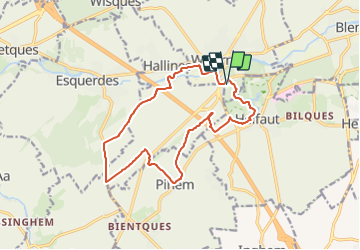

Lengte
13,8 km

Max. hoogte
121 m

Positief hoogteverschil
203 m
Km-Effort
16,5 km

Min. hoogte
23 m

Negatief hoogteverschil
203 m
Boucle
Ja
Datum van aanmaak :
2019-04-20 15:41:53.242
Laatste wijziging :
2019-04-20 15:43:33.742
3h36
Moeilijkheid : Medium

Gratisgps-wandelapplicatie
 SityTrail
IGN / Geografische instituten
SityTrail Plus
De wereld gaat voor u open
Over ons
Tocht Stappen van 13,8 km beschikbaar op Hauts-de-France, Pas-de-Calais, Wizernes. Deze tocht wordt voorgesteld door alain62rando.
Plaatsbepaling
Land:
France
Regio :
Hauts-de-France
Departement/Provincie :
Pas-de-Calais
Gemeente :
Wizernes
Locatie:
Unknown
Vertrek:(Dec)
Vertrek:(UTM)
445717 ; 5617268 (31U) N.
Opmerkingen