


la côte d ecuiry

hm
Gebruiker
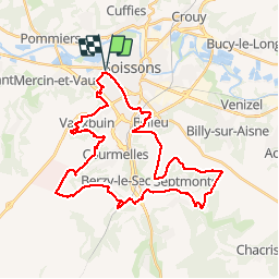

Lengte
35 km

Max. hoogte
156 m

Positief hoogteverschil
451 m
Km-Effort
41 km

Min. hoogte
41 m

Negatief hoogteverschil
451 m
Boucle
Ja
Datum van aanmaak :
2019-04-28 07:00:32.624
Laatste wijziging :
2019-04-28 09:52:06.956
2h50
Moeilijkheid : Medium

Gratisgps-wandelapplicatie
 SityTrail
IGN / Geografische instituten
SityTrail Plus
De wereld gaat voor u open
Over ons
Tocht Mountainbike van 35 km beschikbaar op Hauts-de-France, Aisne, Soissons. Deze tocht wordt voorgesteld door hm.
Plaatsbepaling
Land:
France
Regio :
Hauts-de-France
Departement/Provincie :
Aisne
Gemeente :
Soissons
Locatie:
Unknown
Vertrek:(Dec)
Vertrek:(UTM)
522358 ; 5469778 (31U) N.
Opmerkingen