


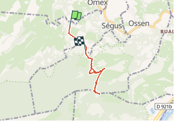
PIBESTE PAR SEGUS

ehresmann
Gebruiker

Lengte
6,3 km

Max. hoogte
1340 m

Positief hoogteverschil
631 m
Km-Effort
14,4 km

Min. hoogte
726 m

Negatief hoogteverschil
530 m
Boucle
Neen
Datum van aanmaak :
2014-12-10 00:00:00.0
Laatste wijziging :
2014-12-10 00:00:00.0
2h55
Moeilijkheid : Medium

Gratisgps-wandelapplicatie
 SityTrail
IGN / Geografische instituten
SityTrail Plus
De wereld gaat voor u open
Over ons
Tocht Stappen van 6,3 km beschikbaar op Occitanië, Hautes-Pyrénées, Ségus. Deze tocht wordt voorgesteld door ehresmann.
Beschrijving
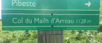
Le chemin est raide
Foto's


Plaatsbepaling
Land:
France
Regio :
Occitanië
Departement/Provincie :
Hautes-Pyrénées
Gemeente :
Ségus
Locatie:
Unknown
Vertrek:(Dec)
Vertrek:(UTM)
736840 ; 4772621 (30T) N.
Opmerkingen