


Sortie à vélo l'après-midi(VAE)

benoit48
Gebruiker

Lengte
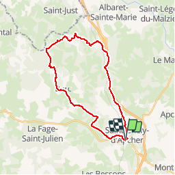
28 km

Max. hoogte
1150 m

Positief hoogteverschil
537 m
Km-Effort
35 km

Min. hoogte
979 m

Negatief hoogteverschil
538 m
Boucle
Ja
Datum van aanmaak :
2019-05-01 10:10:01.086
Laatste wijziging :
2019-05-01 10:11:33.587
2h00
Moeilijkheid : Gemakkelijk

Gratisgps-wandelapplicatie
 SityTrail
IGN / Geografische instituten
SityTrail Plus
De wereld gaat voor u open
Over ons
Tocht Mountainbike van 28 km beschikbaar op Occitanië, Lozère, Saint-Chély-d'Apcher. Deze tocht wordt voorgesteld door benoit48.
Plaatsbepaling
Land:
France
Regio :
Occitanië
Departement/Provincie :
Lozère
Gemeente :
Saint-Chély-d'Apcher
Locatie:
Unknown
Vertrek:(Dec)
Vertrek:(UTM)
521694 ; 4960474 (31T) N.
Opmerkingen