


saint-chely saint martin

frank12
Gebruiker
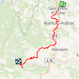

Lengte
102 km

Max. hoogte
1394 m

Positief hoogteverschil
2621 m
Km-Effort
138 km

Min. hoogte
425 m

Negatief hoogteverschil
2994 m
Boucle
Neen
Datum van aanmaak :
2019-05-05 10:01:35.252
Laatste wijziging :
2019-05-05 10:05:51.743
4h00
Moeilijkheid : Gemakkelijk

Gratisgps-wandelapplicatie
 SityTrail
IGN / Geografische instituten
SityTrail Plus
De wereld gaat voor u open
Over ons
Tocht Moto-cross van 102 km beschikbaar op Occitanië, Lozère, Saint-Chély-d'Apcher. Deze tocht wordt voorgesteld door frank12.
Plaatsbepaling
Land:
France
Regio :
Occitanië
Departement/Provincie :
Lozère
Gemeente :
Saint-Chély-d'Apcher
Locatie:
Unknown
Vertrek:(Dec)
Vertrek:(UTM)
521815 ; 4960552 (31T) N.
Opmerkingen
Bonjour, je viens de voir votre rando et j'aimerai savoir avec quel type de moto vous l'avez faite ? Pour ma par j'ai une Africa Twin 1000CRF. Pensez vous que cette rando et les autres que vous avez publiées sont faisables avec mon trail ? Merci de votre réponse