


golignac

FLORENSAC
Gebruiker
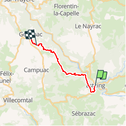

Lengte
17,2 km

Max. hoogte
666 m

Positief hoogteverschil
623 m
Km-Effort
24 km

Min. hoogte
312 m

Negatief hoogteverschil
298 m
Boucle
Neen
Datum van aanmaak :
2019-05-05 05:26:46.621
Laatste wijziging :
2019-05-05 12:26:04.803
6h20
Moeilijkheid : Heel gemakkelijk

Gratisgps-wandelapplicatie
 SityTrail
IGN / Geografische instituten
SityTrail Plus
De wereld gaat voor u open
Over ons
Tocht Stappen van 17,2 km beschikbaar op Occitanië, Aveyron, Estaing. Deze tocht wordt voorgesteld door FLORENSAC.
Plaatsbepaling
Land:
France
Regio :
Occitanië
Departement/Provincie :
Aveyron
Gemeente :
Estaing
Locatie:
Unknown
Vertrek:(Dec)
Vertrek:(UTM)
473948 ; 4933379 (31T) N.
Opmerkingen