


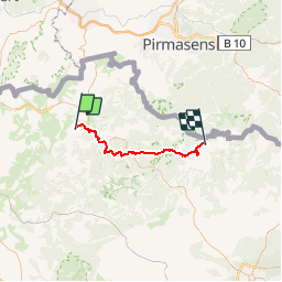
Circuit VDN Siersthal Obersteinbach

Tourisme Equestre Alsace
Promouvoir le Tourisme Equestre en Alsace GUIDE+

Lengte
38 km

Max. hoogte
408 m

Positief hoogteverschil
816 m
Km-Effort
49 km

Min. hoogte
225 m

Negatief hoogteverschil
897 m
Boucle
Neen
Datum van aanmaak :
2015-08-04 00:00:00.0
Laatste wijziging :
2019-01-05 18:43:16.838
6h01
Moeilijkheid : Zeer moeilijk

Gratisgps-wandelapplicatie
 SityTrail
IGN / Geografische instituten
SityTrail Plus
De wereld gaat voor u open
Over ons
Tocht Paardrijden van 38 km beschikbaar op Grand Est, Moselle, Siersthal. Deze tocht wordt voorgesteld door Tourisme Equestre Alsace.
Foto's


Plaatsbepaling
Land:
France
Regio :
Grand Est
Departement/Provincie :
Moselle
Gemeente :
Siersthal
Locatie:
Unknown
Vertrek:(Dec)
Vertrek:(UTM)
379429 ; 5435409 (32U) N.
Opmerkingen