


pont saint esprid

mthomas30
Gebruiker
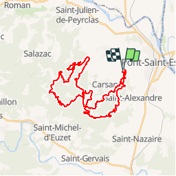

Lengte
41 km

Max. hoogte
358 m

Positief hoogteverschil
1058 m
Km-Effort
55 km

Min. hoogte
113 m

Negatief hoogteverschil
1052 m
Boucle
Ja
Datum van aanmaak :
2019-05-12 05:36:59.208
Laatste wijziging :
2019-05-12 10:00:54.639
4h22
Moeilijkheid : Gemakkelijk

Gratisgps-wandelapplicatie
 SityTrail
IGN / Geografische instituten
SityTrail Plus
De wereld gaat voor u open
Over ons
Tocht Mountainbike van 41 km beschikbaar op Occitanië, Gard, Pont-Saint-Esprit. Deze tocht wordt voorgesteld door mthomas30.
Plaatsbepaling
Land:
France
Regio :
Occitanië
Departement/Provincie :
Gard
Gemeente :
Pont-Saint-Esprit
Locatie:
Unknown
Vertrek:(Dec)
Vertrek:(UTM)
628673 ; 4900639 (31T) N.
Opmerkingen