


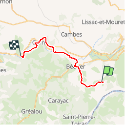
Faycelles StEulalie J1+

kephas
Gebruiker

Lengte
18,4 km

Max. hoogte
349 m

Positief hoogteverschil
289 m
Km-Effort
23 km

Min. hoogte
167 m

Negatief hoogteverschil
443 m
Boucle
Neen
Datum van aanmaak :
2019-05-14 07:44:15.997
Laatste wijziging :
2019-05-14 16:09:33.196
7h25
Moeilijkheid : Gemakkelijk

Gratisgps-wandelapplicatie
 SityTrail
IGN / Geografische instituten
SityTrail Plus
De wereld gaat voor u open
Over ons
Tocht Stappen van 18,4 km beschikbaar op Occitanië, Lot, Faycelles. Deze tocht wordt voorgesteld door kephas.
Foto's


Plaatsbepaling
Land:
France
Regio :
Occitanië
Departement/Provincie :
Lot
Gemeente :
Faycelles
Locatie:
Unknown
Vertrek:(Dec)
Vertrek:(UTM)
419396 ; 4935204 (31T) N.
Opmerkingen