


SityTrail - 937033 - ecrainville-2

doboul
Gebruiker

Lengte
9,4 km

Max. hoogte
131 m

Positief hoogteverschil
112 m
Km-Effort
10,9 km

Min. hoogte
88 m

Negatief hoogteverschil
110 m
Boucle
Ja
Datum van aanmaak :
2019-05-16 15:00:22.545
Laatste wijziging :
2019-05-16 15:00:22.545
--
Moeilijkheid : Onbekend

Gratisgps-wandelapplicatie
 SityTrail
IGN / Geografische instituten
SityTrail Plus
De wereld gaat voor u open
Over ons
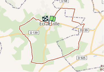
Tocht Stappen van 9,4 km beschikbaar op Normandië, Seine-Maritime, Écrainville. Deze tocht wordt voorgesteld door doboul.
Beschrijving
Plaine et chemins herbus
Plaatsbepaling
Land:
France
Regio :
Normandië
Departement/Provincie :
Seine-Maritime
Gemeente :
Écrainville
Locatie:
Unknown
Vertrek:(Dec)
Vertrek:(UTM)
306899 ; 5503129 (31U) N.
Opmerkingen