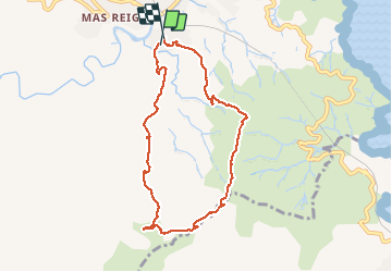
9,3 km | 14,9 km-effort
banyuls_ColCerbere_T
force
Gebruiker
Lengte
8,2 km
Max. hoogte
447 m
Positief hoogteverschil
434 m
Km-Effort
13,9 km
Min. hoogte
13 m
Negatief hoogteverschil
430 m
Boucle
Ja
Datum van aanmaak :
2019-05-19 12:11:33.32
Laatste wijziging :
2019-06-22 12:03:44.52
2h47
Moeilijkheid : Heel gemakkelijk
Gratisgps-wandelapplicatie
Over ons
Tocht Stappen van 8,2 km beschikbaar op Occitanië, Pyrénées-Orientales, Banyuls-sur-Mer. Deze tocht wordt voorgesteld door force.
Plaatsbepaling
Land:
France
Regio :
Occitanië
Departement/Provincie :
Pyrénées-Orientales
Gemeente :
Banyuls-sur-Mer
Locatie:
Unknown
Vertrek:(Dec)
Vertrek:(UTM)
510282 ; 4702159 (31T) N.
Opmerkingen
Wandeltochten in de omgeving
66 COLLIOURE - les balcons de Madeloc - circuit de la tour et des fortificati...
Stappen
Moeilijk
(1)
Collioure,
Occitanië,
Pyrénées-Orientales,
France
2h 4min
Ja
PORT-VENDRES 66 - Sentier littoral jusqu'à BANYULS-SUR-MER - retour par l'arr...
Stappen
Medium
(2)
Port-Vendres,
Occitanië,
Pyrénées-Orientales,
France
10,1 km | 14 km-effort
2h 21min
Ja
BANYULS- SUR-MER 66 - Sentier littoral - cap Rederis - col de la Creu
Stappen
Moeilijk
(2)
Banyuls-sur-Mer,
Occitanië,
Pyrénées-Orientales,
France
15,1 km | 22 km-effort
3h 45min
Ja
COLLIOURE 66 - Ermitage ND de consolation - tour MADELOC
Stappen
Moeilijk
(4)
Collioure,
Occitanië,
Pyrénées-Orientales,
France
14,7 km | 23 km-effort
3h 41min
Ja
Littoral Banyuls-Cerbere
Stappen
Medium
(1)
Banyuls-sur-Mer,
Occitanië,
Pyrénées-Orientales,
France
13,6 km | 18,8 km-effort
4h 33min
Ja
Banyuls Cerbère - Littoral retour bus - 10km 4h 320m déniv.
Stappen
Moeilijk
(1)
Banyuls-sur-Mer,
Occitanië,
Pyrénées-Orientales,
France
10 km | 14,3 km-effort
4h 12min
Neen
RP 66 BANYULS SUR MER - PUIG del Mas - PUIG JOAN - le 10.03.2017
Stappen
Medium
(1)
Banyuls-sur-Mer,
Occitanië,
Pyrénées-Orientales,
France
9,7 km | 16 km-effort
2h 21min
Ja
tour de Madeloc
Stappen
Medium
(1)
Collioure,
Occitanië,
Pyrénées-Orientales,
France
9,5 km | 15,1 km-effort
3h 21min
Ja