


Lespinassière

DENNEBECQ
Gebruiker

Lengte
17,9 km

Max. hoogte
961 m

Positief hoogteverschil
699 m
Km-Effort
27 km

Min. hoogte
440 m

Negatief hoogteverschil
706 m
Boucle
Ja
Datum van aanmaak :
2019-06-09 07:26:28.838
Laatste wijziging :
2019-06-09 21:11:25.177
5h24
Moeilijkheid : Medium

Gratisgps-wandelapplicatie
 SityTrail
IGN / Geografische instituten
SityTrail Plus
De wereld gaat voor u open
Over ons
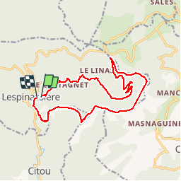
Tocht Stappen van 17,9 km beschikbaar op Occitanië, Aude, Lespinassière. Deze tocht wordt voorgesteld door DENNEBECQ.
Plaatsbepaling
Land:
France
Regio :
Occitanië
Departement/Provincie :
Aude
Gemeente :
Lespinassière
Locatie:
Unknown
Vertrek:(Dec)
Vertrek:(UTM)
462945 ; 4805749 (31T) N.
Opmerkingen