Tocht Noords wandelen Téteghem-Coudekerque-Village - 
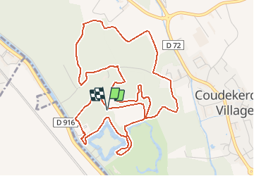
Circuit du Bois des Forts - Photo
 denissculier
denissculier

Gebruiker

© OpenStreetMap contributors
Lengte
Lengte
6,4 km
Max. hoogte
Max. hoogte
8 m
Positief hoogteverschil
30 m
Km-Effort
Km-Effort  
6,8 km
Min. hoogte
Min. hoogte
-4 m
Negatief hoogteverschil
31 m
Boucle
Boucle
Ja
Datum van aanmaak :
2019-06-16 10:00:16.583
Laatste wijziging :
2021-03-27 16:58:26.637

(0 Bericht)

Noords wandelen
Noords wandelen
1h31
Moeilijkheid : Gemakkelijk

Scan deze QR-code om de tocht te openen in de SityTrail-applicatie

Gratisgps-wandelapplicatie

Logo SityTrail SityTrail

IGN / Geografische instituten

SityTrail uit de App Store downloaden SityTrail uit Google Play downloaden

Logo SityTrail SityTrail Plus

De wereld gaat voor u open

SityTrail uit de App Store downloaden SityTrail uit Google Play downloaden SityTrail op Huawei AppGallery downloaden

Over ons

Tocht Noords wandelen van 6,4 km beschikbaar op Hauts-de-France, Noorderdepartement, Téteghem-Coudekerque-Village. Deze tocht wordt voorgesteld door denissculier.

Beschrijving

Circuit à la découverte du bois des Forts. Ce bois, créé par la Communauté Urbaine de Dunkerque, abrite de nombreux oiseaux et constitue la partie Sud d’une grande couronne verte ceinturant l’agglomération. Les sentiers bitumés ou schisteux permettent une pratique par tous, toute l’année. Balisage jaune.

Hoogteprofiel

Plaatsbepaling

Land:
France
Regio :
Hauts-de-France
Departement/Provincie :
Noorderdepartement
Gemeente :
Téteghem-Coudekerque-Village
Locatie:
Unknown
Vertrek:(UTM)
458002 ; 5649313 (31U) N.


Sluiten
Mijn abonnementen