Tocht Stappen Saint-Michel-sur-Meurthe - les Jumeaux  - Photo
 patandre
patandre

Gebruiker

© OpenStreetMap contributors
Lengte
Lengte
6,1 km
Max. hoogte
Max. hoogte
547 m
Positief hoogteverschil
276 m
Km-Effort
Km-Effort  
9,8 km
Min. hoogte
Min. hoogte
398 m
Negatief hoogteverschil
275 m
Boucle
Boucle
Ja
Datum van aanmaak :
2019-06-18 12:13:42.277
Laatste wijziging :
2019-06-18 14:55:47.044

(0 Bericht)

Stappen
Stappen
2h27
Moeilijkheid : Heel gemakkelijk

Scan deze QR-code om de tocht te openen in de SityTrail-applicatie

Gratisgps-wandelapplicatie

Logo SityTrail SityTrail

IGN / Geografische instituten

SityTrail uit de App Store downloaden SityTrail uit Google Play downloaden

Logo SityTrail SityTrail World

De wereld gaat voor u open

SityTrail uit de App Store downloaden SityTrail uit Google Play downloaden SityTrail op Huawei AppGallery downloaden

Over ons

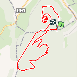
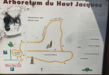
Tocht Stappen van 6,1 km beschikbaar op Grand Est, Vogezen, Saint-Michel-sur-Meurthe. Deze tocht wordt voorgesteld door patandre.

Beschrijving

Rando de l'après midi
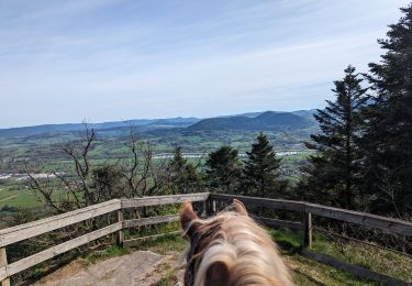
Hoogteprofiel

Plaatsbepaling

Land:
France
Regio :
Grand Est
Departement/Provincie :
Vogezen
Gemeente :
Saint-Michel-sur-Meurthe
Locatie:
Unknown
Vertrek:(UTM)
340827 ; 5353357 (32U) N.

Wandeltochten in de omgeving

Tocht Paardrijden Nompatelize - suuntoapp-HorsebackRiding-2024-04-13T07-02-45Z - Photo
Paardrijden
GUIDE
holtzv

Paardrijden

Medium
(1)
Nompatelize, Grand Est, Vogezen, France
28 km | 37 km-effort
4h 54min
Ja
Tocht Mountainbike Saint-Dié-des-Vosges - vtt la voivre La Bure 29-03-19 - Photo
Mountainbike
vathi54

Mountainbike

Moeilijk
(2)
Saint-Dié-des-Vosges, Grand Est, Vogezen, France
20 km | 28 km-effort
2h 48min
Ja
Tocht Stappen Saint-Michel-sur-Meurthe - massif de la madeleine  - Photo
Stappen
remysimon

Stappen

Medium
(1)
Saint-Michel-sur-Meurthe, Grand Est, Vogezen, France
14,7 km | 22 km-effort
4h 10min
Ja
Tocht Mountainbike La Bourgonce - sortie vtt du 07042019 la bourgonce - Photo
Mountainbike
GUIDE
fabwin

Mountainbike

Moeilijk
La Bourgonce, Grand Est, Vogezen, France
31 km | 42 km-effort
2h 48min
Ja
Tocht Mountainbike La Bourgonce - vtt à Bourgonce 26 juin 2016 - Photo
Mountainbike
vathi54

Mountainbike

Heel gemakkelijk
(2)
La Bourgonce, Grand Est, Vogezen, France
31 km | 42 km-effort
3h 39min
Ja
Tocht Stappen Saint-Dié-des-Vosges - Autour de CAP FRANCE LA BOLLE VOSGES - Photo
Stappen
Dominique48

Stappen

Medium
Saint-Dié-des-Vosges, Grand Est, Vogezen, France
5,9 km | 8,8 km-effort
2h 14min
Neen
Tocht Te voet Saint-Michel-sur-Meurthe - Circuit du Grand Jumeau - Photo
Te voet
PRO

Te voet

Gemakkelijk
Saint-Michel-sur-Meurthe, Grand Est, Vogezen, France
3,7 km | 5,8 km-effort
1h 18min
Ja
Tocht Te voet Les Rouges-Eaux - circuit poussettes du col du Haut Jacques  - Photo
Te voet
salomé

Te voet

Gemakkelijk
Les Rouges-Eaux, Grand Est, Vogezen, France
1,4 km | 1,6 km-effort
21min
Ja
Tocht Mountainbike Saint-Dié-des-Vosges - sortie vtt du 31032019 - Photo
Mountainbike
GUIDE
fabwin

Mountainbike

Medium
Saint-Dié-des-Vosges, Grand Est, Vogezen, France
18,6 km | 0 m-effort
1h 41min
Ja


Sluiten
Mijn abonnementen