


![Tocht Stappen Nogaro - [28] Compostelle : de Nogaro à Barcelonne-du-Gers - Photo](https://media.geolcdn.com/t/1900/400/ext.pjpeg?maxdim=2&url=https%3A%2F%2Fstatic1.geolcdn.com%2Fsiteimages%2Fupload%2Ffiles%2F1553511878bg_sport_marche.png)
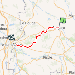
[28] Compostelle : de Nogaro à Barcelonne-du-Gers

phimar_2612
Gebruiker

Lengte
26 km

Max. hoogte
166 m

Positief hoogteverschil
305 m
Km-Effort
30 km

Min. hoogte
82 m

Negatief hoogteverschil
318 m
Boucle
Neen
Datum van aanmaak :
2019-06-20 05:41:02.363
Laatste wijziging :
2019-06-20 11:26:50.522
5h15
Moeilijkheid : Gemakkelijk

Gratisgps-wandelapplicatie
 SityTrail
IGN / Geografische instituten
SityTrail Plus
De wereld gaat voor u open
Over ons
Tocht Stappen van 26 km beschikbaar op Occitanië, Gers, Nogaro. Deze tocht wordt voorgesteld door phimar_2612.
Plaatsbepaling
Land:
France
Regio :
Occitanië
Departement/Provincie :
Gers
Gemeente :
Nogaro
Locatie:
Unknown
Vertrek:(Dec)
Vertrek:(UTM)
738807 ; 4849563 (30T) N.
Opmerkingen