


lac de lignin

CASSISFRAMBOISE
Gebruiker

Lengte
18,1 km

Max. hoogte
2293 m

Positief hoogteverschil
690 m
Km-Effort
27 km

Min. hoogte
1641 m

Negatief hoogteverschil
722 m
Boucle
Neen
Datum van aanmaak :
2019-07-01 04:49:12.461
Laatste wijziging :
2019-07-02 14:27:38.506
5h17
Moeilijkheid : Medium

Gratisgps-wandelapplicatie
 SityTrail
IGN / Geografische instituten
SityTrail Plus
De wereld gaat voor u open
Over ons
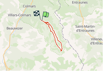
Tocht Stappen van 18,1 km beschikbaar op Provence-Alpes-Côte d'Azur, Alpes-de-Haute-Provence, Colmars. Deze tocht wordt voorgesteld door CASSISFRAMBOISE.
Beschrijving
superbes vues...chemins et sentiers agreables
Plaatsbepaling
Land:
France
Regio :
Provence-Alpes-Côte d'Azur
Departement/Provincie :
Alpes-de-Haute-Provence
Gemeente :
Colmars
Locatie:
Unknown
Vertrek:(Dec)
Vertrek:(UTM)
312732 ; 4891811 (32T) N.
Opmerkingen