


col della Barma

BerardoDaniel
Gebruiker
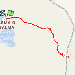

Lengte
2,3 km

Max. hoogte
2251 m

Positief hoogteverschil
204 m
Km-Effort
5,1 km

Min. hoogte
2039 m

Negatief hoogteverschil
204 m
Boucle
Ja
Datum van aanmaak :
2019-07-06 06:20:54.127
Laatste wijziging :
2019-07-06 08:05:55.047
1h42
Moeilijkheid : Heel gemakkelijk

Gratisgps-wandelapplicatie
 SityTrail
IGN / Geografische instituten
SityTrail Plus
De wereld gaat voor u open
Over ons
Tocht Stappen van 2,3 km beschikbaar op Valle d'Aosta, Onbekend, Fontainemore. Deze tocht wordt voorgesteld door BerardoDaniel.
Plaatsbepaling
Land:
Italy
Regio :
Valle d'Aosta
Departement/Provincie :
Onbekend
Gemeente :
Fontainemore
Locatie:
Unknown
Vertrek:(Dec)
Vertrek:(UTM)
416586 ; 5055090 (32T) N.
Opmerkingen