


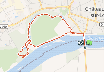
Chateauneuf sur Loire - le parc

ace003
Gebruiker


1h33
Moeilijkheid : Heel gemakkelijk

Gratisgps-wandelapplicatie
 SityTrail
IGN / Geografische instituten
SityTrail Plus
De wereld gaat voor u open
Over ons
Tocht Stappen van 6,2 km beschikbaar op Centre-Val de Loire, Loiret, Sigloy. Deze tocht wordt voorgesteld door ace003.
Beschrijving
Une belle balade en boucle dans le parc de chateauneuf sur Loire.
Départ et arrivée : avant le pont dans l'allée du camping.
Guide réalisé le 17 aout 2013.
Foto's


21 fotos in totaal. Klik op een foto om ze allemaal in de galerij weer te geven.


Plaatsbepaling
Opmerkingen