


20190715chartes

Jeanclaudebic
Gebruiker

Lengte
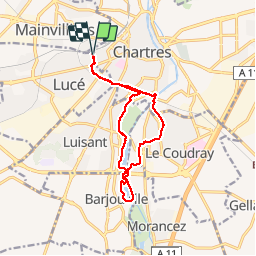
12,1 km
Boucle
Ja
Datum van aanmaak :
2019-07-15 05:38:57.8
Laatste wijziging :
2019-07-15 07:58:37.871
2h19
Moeilijkheid : Heel gemakkelijk

Gratisgps-wandelapplicatie
 SityTrail
IGN / Geografische instituten
SityTrail Plus
De wereld gaat voor u open
Over ons
Tocht Stappen van 12,1 km beschikbaar op Centre-Val de Loire, Eure-et-Loir, Lucé. Deze tocht wordt voorgesteld door Jeanclaudebic.
Plaatsbepaling
Land:
France
Regio :
Centre-Val de Loire
Departement/Provincie :
Eure-et-Loir
Gemeente :
Lucé
Locatie:
Unknown
Vertrek:(Dec)
Vertrek:(UTM)
386952 ; 5366683 (31U) N.
Opmerkingen