


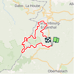
VTT autour du schneeberg

oscar1
Gebruiker

Lengte
27 km

Max. hoogte
928 m

Positief hoogteverschil
759 m
Km-Effort
37 km

Min. hoogte
488 m

Negatief hoogteverschil
761 m
Boucle
Ja
Datum van aanmaak :
2019-07-23 09:16:35.402
Laatste wijziging :
2019-07-23 16:22:38.331
3h20
Moeilijkheid : Heel gemakkelijk

Gratisgps-wandelapplicatie
 SityTrail
IGN / Geografische instituten
SityTrail Plus
De wereld gaat voor u open
Over ons
Tocht Mountainbike van 27 km beschikbaar op Grand Est, Bas-Rhin, Cosswiller. Deze tocht wordt voorgesteld door oscar1.
Plaatsbepaling
Land:
France
Regio :
Grand Est
Departement/Provincie :
Bas-Rhin
Gemeente :
Cosswiller
Locatie:
Unknown
Vertrek:(Dec)
Vertrek:(UTM)
375838 ; 5383202 (32U) N.
Opmerkingen